
2011-12-31
2011-12-20

2011-12-13

2011-12-10
Lunar Eclipse
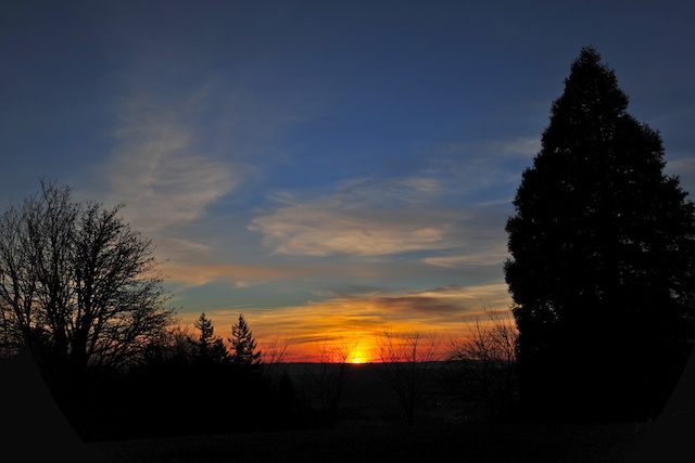
Stood in 29F temperature with wind gusts up to 50mph (wind chill factor 10F) for 2 hours just to get a few pictures of the last lunar eclipse until 2014. From Crown Point on the Columbia Gorge.
 |
| Lunar Eclipse of 2011 |
2011-12-09
Moon Rise over Columbia Gorge
On an afternoon when wind gusts were reaching 77 mph at Crown Point above the Columbia Gorge, one should be grateful to capture the moon rise through the haze.
 |
| Moon rising above Vista House at Crown Point |
2011-12-06
A Walk in "Grimm" Park
 |
| Foggy Day in Forest Park by Upper MacCleay Trail where part of the TV Series Grimm was filmed. |
Portland Skyline
 |
| Portland Skyline and Mount Hood from Pittock Mansion |
 |
| Downtown Portland and Mount Hood from Vista Bridge |
 |
| A not so common sight: Mt Rainier, Mt St. Helens and Mt Adams from Council Crest |
2011-12-01

2011-11-12

2011-11-11
Vista House at Crown Point
Crown Point on the Historic Columbia Gorge Highway just east of Corbett, OR is an excellent location to view sunsets and moon rises.
 |
| Vista House on Crown Point viewed from Portland's Women Forum |
 |
| Sunset illuminating Vista House |
2011-11-06

2011-11-02

2011-10-29


2011-10-26
"Halloween" Sunrise
 |
| Fall Sunrise at Portland Council Crest (straight from camera!) |
 |
| Leaves in Morning Light |
2011-09-29
Rainbow in an odd place
While taking dawn pictures of the Portland Skyline from the Pittock Mansion, this shot came along with a rainbow on top of Mount Hood under a cloudless sky ;-)
 |
| Notice the rainbow (effect) on top of Mount Hood |
2011-09-11
Looking for the Moon, Settled for the Sun
Haze obscured the moon rising over Mount Hood, but as serendipity would have it, it was a gorgeous sunset.
 |
| Late Summer Sunset as viewed from Portland's Council Crest |
 |
2011-08-18
Panther Creek Falls
Panther Creek Falls (130 ft) in Gifford Pinchot National Forest is a combination of falls from Panther Creek and springs which feed the tallest drops. Furthermore Panther Creek splits into two with the majority of the water swirling around a 270 degree turn before gushing down while a small section flows straight and forms a straight waterfall away from the main drop.
Panther Creek Falls is located about 20 miles north of Cascade Locks on Panther Creek Road, which is just off the Old State Road off Wind River Road north of Carson, Wa. A big gravel parking area welcomes you. The trailhead to the observation deck is across the street on the south end of the parking area. The base of the falls can be reached by scaling a small cliff and down a steep trail but the rewards are worth it.
Panther Creek Falls is located about 20 miles north of Cascade Locks on Panther Creek Road, which is just off the Old State Road off Wind River Road north of Carson, Wa. A big gravel parking area welcomes you. The trailhead to the observation deck is across the street on the south end of the parking area. The base of the falls can be reached by scaling a small cliff and down a steep trail but the rewards are worth it.
 |
| View of Parking Area looking towards trail head |
 |
| Trail head |
 |
| Viewing Platform with Falls in background |
 |
| Trail to bottom of Falls |
 |
| Small Cliff |
 |
| View of Panther Creek Fall from the Viewing Platform |
 |
| Panther Creek right before the Falls |
 |
| View of Panther Creek Falls from the Base |
 |
| The drops on the left are from springs, whereas the heavy fall on the right is from Panther Creek. |
 |
| Full view of the Falls with the straight drop from Panther Creek on the very right. |
2011-08-17
Further Columbia Gorge Falls
Latourell Falls Trailhead is located about 3 miles west of Bridal Veil Falls on the Historic Columbia Gorge Highway. The Lower Falls (224 ft) are a stones throw from the parking lot, the Upper Falls (120 ft) about a mile hike up. But the fall is well worth the initial fairly steep climb.
Dry Creek Falls (75 ft) lies a couple hundred yards off the Pacific Crest Trail about 2 miles from the PCT South trailhead in Cascade Locks. Look for the PCT sign, head up the trail and turn south right before you reach the bridge crossing Dry Creek.
At Starvation Creek State Park off Exit 55 on Highway 84 (east only) you can view four waterfalls with only a 2 mile roundtrip hike. Starvation Creek Falls (186 ft total, 100 ft longest drop) is right by the trailhead and if you head west along the trail which starts out hugging the freeway, you find Cabin Creek (220 ft/130 ft), Hole-in-the-Wall (96 ft/63ft), and Lancaster Falls (303 ft/231 ft) in rapid succession.
 |
| Lower Latourell Falls |
 |
| Upper Latourell Falls |
 |
| Upper Latourell Falls |
 |
| Trail head |
 |
| Along PCT Trail |
 |
| Bridge over Dry Creek |
 |
| Dry Creek Fall |
 |
| Dry Creek Fall |
 |
| Starvation Creek Falls |
 |
| Starvation Creek |
 |
| Cabin Creek Falls |
 |
| Hole in the Wall Falls |
 |
| Lancaster Falls |
 |
| Lancaster Falls |
2011-08-12


More Columbia Gorge Falls: Fairy, Horsetail, Elowah, and Wahclella Falls
Fairy Falls (20 ft) is about 1.5 mile up the Wahkeena Trail just west of Multnomah Falls. Along the way you hike along some beautiful sections of the Wahkeena Creek.
Horsetail Falls (214 ft) lies about 3 miles east of Wahkeena Falls right along the historic Columbia River Highway. No hiking required for this view.
Another 9 miles east, an easy 1 mile hike from the John B Yeon trailhead lies the 213 ft Elowah Falls and McCord Creek.
Continuing east about 2 miles, right off the Bonneville Dam exit is the trailhead to Wahclella Falls (total height 127 ft, tallest drop 79 ft). An easy one mile hike leads to a majestic waterfall.
 |
| Wahkeena Creek |
 |
| Fairy Falls |
 |
| Another View of Fairy Falls |
Horsetail Falls (214 ft) lies about 3 miles east of Wahkeena Falls right along the historic Columbia River Highway. No hiking required for this view.
 |
| Horsetail Falls |
Another 9 miles east, an easy 1 mile hike from the John B Yeon trailhead lies the 213 ft Elowah Falls and McCord Creek.
 |
| McCord Creek |
 |
| Elowah Falls |
Continuing east about 2 miles, right off the Bonneville Dam exit is the trailhead to Wahclella Falls (total height 127 ft, tallest drop 79 ft). An easy one mile hike leads to a majestic waterfall.
 |
| Wahclella Falls |
Subscribe to:
Posts (Atom)